# 48 Agents Found a Maya Pyramid—and Missed Page 14 of the Paper They Cited
Published: 2026-11-22 · Language: en
Original: https://yage.ai/share/maya-lidar-agents-rediscovery-en-20261122.html
Publisher: Superlinear Academy · 100% AI generated
[Article index](https://yage.ai/share/llms.txt)
[Other language](https://yage.ai/share/maya-lidar-agents-rediscovery-20261122.html)
When people build AI agent workflows today, the most common playbook has two steps: spin up dozens of agents in parallel to scan logs, code, or images for anomalies, then ask them to search documents and databases to verify whether anyone has already found the issue. The first half usually flies. The breakdown tends to happen in the second half that looks effortless.
In November 2026, Pietro Miotti, an AI researcher in Google’s Zurich office, shared a weekend experiment online. Without using company compute, he ran 48 general-purpose multimodal agents on his personal laptop to scan 1,200 square kilometers of public terrain data from Mexico’s tropical rainforest—and found a real Maya pyramid hidden beneath dense forest canopy. Mexico’s national archaeological agency replied that no registered site existed at those coordinates in its official archives.
The day after the post went viral on Hacker News, archaeologists pointed out on social media that while the site was genuine and the agents had not hallucinated it, it had already been published in an academic paper in October 2025. Even more telling, that exact paper was listed in the recommended reading section at the bottom of Miotti’s own blog post, with a map of the pyramid printed on page 14.
How could 48 agents see straight through more than ten meters of rainforest canopy and still miss a single page of a PDF sitting in their own bibliography? Looking at the two halves of the pipeline side by side reveals the most overlooked blind spot in today’s agent deduplication workflows.
## Without Training a Custom Model, How Did 48 General Agents Find a Real Pyramid in 72 Hours?
Finding ancient structures under dense forest relies on airborne lidar. The principle is simple: an aircraft fires dense pulses of laser light down toward the jungle. Most beams bounce off the leaves, but a small fraction slips through gaps in the canopy, hits the ground, and returns. Filter out the canopy signals and keep only the ground returns, and you can effectively strip the forest bare to reveal the topography underneath.
In 2013, NASA flew narrow survey strips across Mexico’s Yucatán Peninsula to measure forest carbon storage and released that lidar dataset publicly online. On October 18, 2026, while traveling in Peru, Miotti chatted with several mainstream LLMs, picked that public dataset, and set out to test whether a non-archaeologist using agents could uncover a lost site.
Previously, using AI to locate archaeological sites meant asking domain experts to label large sets of training examples and training specialized image-segmentation models. Miotti skipped training altogether. He sliced the 1,200 square kilometers of lidar strips into hundreds of 2D terrain tiles and handed 48 general-purpose multimodal agents a plain-language visual guide. The core rule was one sentence: nature does not make straight lines—look for straight-edged rectangular platforms, leveled plazas, and raised pyramids, and skip smooth natural hills, sinkholes, and modern roads.
The 48 agents ran overnight and flagged several candidate locations by the morning of October 19. After a few hours of literature searches, one cliff-edge hilltop complex remained as the sole surviving candidate: a leveled rectangular plaza, an 8–12 meter oval pyramid, raised courtyards, and a depression resembling an ancient reservoir.
To rule out an image-processing artifact, on October 20 Miotti had an agent pull the raw laser-scan cross-section at that spot. Viewed from the side, 10 to 17 meters of dense foliage sat on top, while the ground beneath clearly rose into an artificial geometric mound. Satisfied, the agents drafted a Spanish-language report with the exact coordinates tucked into a confidential annex and emailed it to Mexico’s National Institute of Anthropology and History (INAH).
Just one day later, on October 21, INAH replied that no registered archaeological site was identified at the reported location in its official archives. On November 10, Miotti published [the blog post recounting his weekend search](https://pietromiotti.com/latest/maya-site/), setting the tech community abuzz. On its own, the first half of the engineering design was genuinely impressive: instead of spending weeks labeling data for a custom model, he paired general multimodal visual reasoning with a physical check against raw laser data, compressing what used to take a specialist team into 72 hours on a laptop.
Comparison showing the visual scanning channel succeeding while the text-based deduplication channel breaks
## The Paper Was Already in the Reading List—Why Did Deduplication Go Completely Blind?
The twist arrived on November 11, when space archaeologist Sarah Parcak pointed out on social media that the cliffside complex had already been mapped and published by a Tulane University team. Miotti promptly added a correction at the top of his post acknowledging it as a rediscovery.
The more revealing detail is what got missed. Scroll to the “Further reading” list at the bottom of Miotti’s original blog post, and item four is [the October 2025 Maya lidar paper](https://www.sciencedirect.com/science/article/pii/S2352409X25003219) by the Tulane University team. Before sending the report, the agents had already found the paper and even put it in the references—yet never recognized that Figure 13 on page 14 depicted the very cliffside pyramid they were looking for.
Why did deduplication fail completely even after the agents found the paper and received an official reply? Putting Miotti’s post-mortem interview with [The Verge](https://www.theverge.com/ai-artificial-intelligence/1032125/ai-agents-maya-site-archeology-discovery) alongside explanations from archaeologists exposes two hidden workflow traps.
The first trap is treating an administrative registry as the complete ground truth. INAH’s reply was worded carefully: there was no *registered* site in its archives. Paper co-author Ivan Šprajc and Sarah Parcak both explained that Mexico’s official registry logs sites that have undergone ground-truthing and formal administrative filing. Tens of thousands of ancient structures mapped remotely from lidar in academic studies have not yet gone through fieldwork verification and formal registration. Whether an agent queries a public database or a human reads an official email saying “not registered,” it is all too easy to translate an administrative gap into “unknown to humanity.”
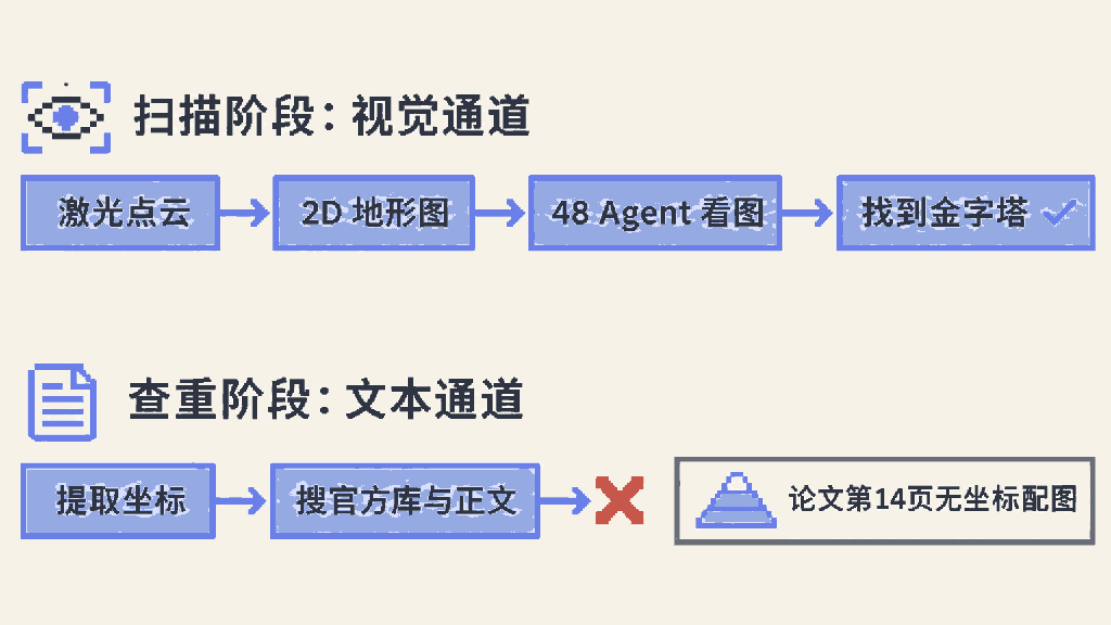
The second trap is subtler: scanning relied on vision, while deduplication fell back to text, leaving the two halves completely mismatched. To prevent looting, archaeology follows a strict norm of omitting exact GPS coordinates from published papers. The 2025 paper contains regional statistics in the text, while four major plaza complexes—including this hilltop pyramid—appear only as unindexed 2D lidar renders on page 14 without text coordinates.
Notice the asymmetry. During scanning, the agents used vision, turning raw laser data into 2D images to spot geometry, and sailed right through. During deduplication, they reverted to text and coordinate queries—searching PDFs that deliberately omit coordinates for a pair of latitude-longitude numbers, which guaranteed an empty result. As Miotti later told reporters, archaeologists rightly withhold coordinates to protect sites, so verifying whether a site is already known requires comparing images against figures inside papers rather than searching a text database—something far harder for today’s agents.
Bring this back to software engineering and everyday office work, and the exact same trap plays out daily. You ask an agent to investigate a bizarre production bug or check whether anyone has tried a product idea before. It searches Jira tickets, repositories, and text docs, then confidently reports that nobody has done it—a brand-new finding. In reality, the team hit that exact wall six months ago, and the conclusion lives in an architecture diagram inside a postmortem slide deck or a screenshot dropped in a chat thread nobody turned into a ticket. Whenever key facts live in images or outside official trackers, pure text search will reliably miss old answers and report back a clean slate.
## Same NASA Dataset, Completely Different Work: What the Specialists Actually Did
An even more surprising fact sits inside that 2025 paper. When Miotti asked LLMs where to look for unmapped ruins, they told him much of NASA’s 2013 forest lidar data had never been closely examined. In fact, that dataset was already well-trodden ground in Maya archaeology. Three research groups screened it between 2016 and 2021. In October 2024, the Tulane team published [a widely covered paper discovering the lost Maya city of Valeriana](https://doi.org/10.15184/aqy.2024.148) from another Mexican forest lidar dataset, and then in 2025 ran a thorough reanalysis of this NASA dataset.
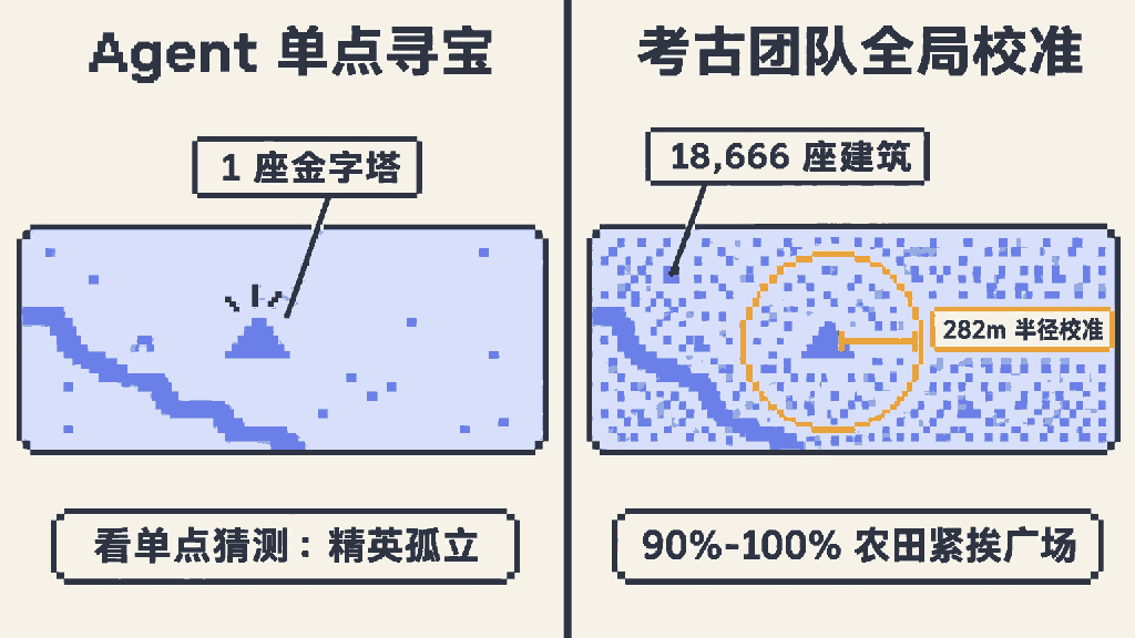
In that 2025 study, 11 analysts at Tulane’s lab reprocessed roughly 500 square kilometers of core NASA raw laser data, with three analysts independently reviewing every tile. Within those NASA strips alone, the human team manually mapped 18,666 Maya structures alongside dense networks of ancient agricultural stone walls and terraces. The hilltop pyramid flagged by Miotti’s 48 agents was simply one of the four most prominent plaza centers out of those 18,666 mapped buildings.
What separates the two efforts is not just the scale of 1 structure versus 18,666—they were answering completely different questions. NASA originally flew those strips to measure forest biomass, so each transect is only about 350 meters wide, slicing through the rainforest like thin noodles. Because the strips are so narrow, their edges slice large settlements in half; simply counting buildings inside the strips produces severe statistical distortion. The core work of the Tulane team was designing a fixed-area statistical window to correct that edge bias, placing those narrow strips on the same calibrated footing as more than 2,000 square kilometers of contiguous survey blocks to the south.
Through that unglamorous statistical calibration, they overturned long-standing consensus: population density in the northern Central Maya Lowlands was actually twice as high as in the south, and 90% to 100% of upland farming settlements lay within 1.5 kilometers of medium plaza centers. Elite ceremonial and market hubs were tightly woven into commoner farmland—people lived close together.
Now look back at Miotti’s blog post. Staring at the single isolated hilltop pyramid his agents surfaced, he chatted with LLMs, had Gemini generate a conceptual reconstruction from the terrain map, and speculated that it was an exclusive hilltop downtown for local elites while commoners lived scattered on the surrounding hills. Looking at one conspicuous outlier and letting an LLM fill in the story produced a narrative of elite-commoner separation—the exact opposite of the tightly integrated density revealed by calibrating the full dataset.
Comparison between single-site agent treasure hunting and full-dataset statistical calibration by archaeologists
This marks the real boundary of agent-assisted research today. Multimodal agents are already capable of spotting a striking anomaly inside noisy data. Yet real scientific and engineering decisions usually depend on counting every mundane sample cleanly, removing sampling bias, and aligning the statistical yardstick across the entire dataset. One is treasure hunting; the other is getting the global picture right.
## When Scanning Costs Approach Zero, Who Pays the Verification Bill?
Frontline archaeologists reacted calmly to the viral 72-hour search. Elizabeth Graham, a Maya archaeologist at University College London, told reporters that the field’s problem has never been finding new sites—researchers working in the Maya region already have a backlog of unexcavated and unmapped locations, and what is actually scarce is the funding to survey and excavate them.
Ivan Šprajc, co-author of the 2025 paper, was even more direct: simply spotting something on a lidar map adds little to human knowledge. On the very day of his interview, he had received an email from another “AI discoverer,” leaving him worried about being flooded by such messages. Back in 2025, OpenAI ran [a \$250,000 Amazon AI archaeology competition](https://www.nationalgeographic.com/science/article/amazon-openai-competition-archaeology-machine-learning-artificial-intelligence) that drew sharp criticism from Brazil’s Ministry of Indigenous Peoples and local scholars over unverified remote-sensing claims and looting risks.
Step back from archaeology, and the same cost curve is playing out across industries. Previously, submitting a Spanish-language report backed by raw laser verification to Mexico’s archaeological agency carried such a high barrier that only trained teams cleared it—and that barrier naturally filtered out most duplicate effort and noise. Today, 48 general-purpose agents running over a weekend can push the cost of collecting public data, screening plausible candidates, and drafting formal reports close to zero.
The cost of generating candidates has dropped by orders of magnitude, while the cost of verifying candidates, running cross-modal deduplication, and confirming them on the ground has not budged. If the sender does not raise the local deduplication bar to match, that expensive verification bill gets dumped straight onto downstream public agencies and human experts. Today it is archaeologists’ inboxes filling up with messages from AI discoverers; tomorrow it will be software engineering, security triage, and peer review facing the exact same congestion.
Miotti’s experiment is a sharp engineering demonstration: general-purpose vision agents can now handle the grunt work of scanning raw data from scratch. The real lesson for anyone building agent pipelines sits on that missed page 14: scaling up parallel scanning is easy, while giving your verification layer the same visual capability as your scanner—and knowing what your databases actually cover—is the hard part. Otherwise, the harder your agent swarm works, the faster it will package answers humans already drew in a figure and mail them off to busy experts as brand-new discoveries.